
July 15th 2024. Icefields Parkway, AB.
Round Trip: +12 Hours, Elevation Gain: 1140m
Moderate Scramble
Further Reading: Nugara’s (2017) More Scrambles in the Canadian Rockies 3rd Edition
An epic and scenic adventure, though things did not quite go according to plan. We were actually aiming for Noseeum Peak that day and wanted to challenge ourselves by taking the “difficult” scrambling route listed in More Scrambles. This route starts from the east side of Noseeum Lake and can be used to traverse Noseeum’s various sub-peaks, including ‘Noseeum 3’ on route to the difficult scramble section. Bri and I were keen to warm up with this difficult route in preparation for the Ledges Route behind Moraine Lake the following week.
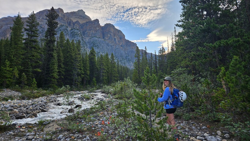
‘Noseeum 3’ we learnt has a local nickname of ‘Bearskin’ Peak, so I shall refer to it as that moving forward. Unlike the difficult route we were after that day, Bearskin Peak itself is an easy-moderate scramble. We did bring a novice scrambler along for this trip, hence the longer round trip time. Fitter/seasoned parties can expect an 8 hour day if only doing Bearskin Peak.
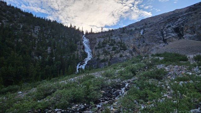
We stuck to Nugara’s (2017) description for this adventure and I believe Bri referenced Bob Spirko’s blog as a second source. Approaching from the Icefields Parkway, we parked at the 1km sign for Mosquito Creek Campground and hiked in along Noseeum Creek. There is a well-defined footpath along the southern bank of the creek. The landscape is already fascinating on the approach as you hike beneath the crumbling northwest cathedral-like slopes of Mount Andromache, aiming for the head waters of the creek which are themselves surrounding by a drastic headwall with several small waterfalls.
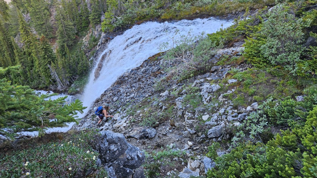
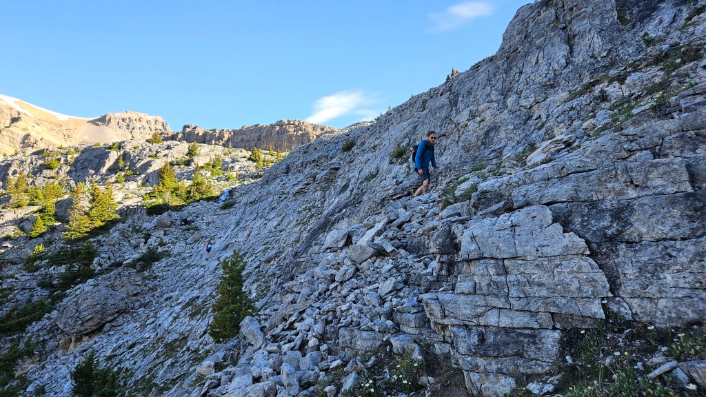
Going off of a photo reference from More Scrambles we aimed for some treed ledges between the leftmost and centre waterfalls. This involved some hands-on scrambling but at a comfortable level. We picked our way up through these ledges and eventually found a faint trail that led through the remaining trees to a second waterfall. For this Upper Waterfall, we decided to scramble up the climber’s right. It was surprisingly sturdy rock given its crumbly appearance, though we acknowledged that downclimbing it later could be nasty.

Above the Upper Waterfall we meandered our way through sup-alpine tundra aiming for a second headwall, all while keeping slightly to the climber’s right. The difficult route listed in More Scrambles circumnavigates the south and eastern edges of Noseeum Lake, so we planned on picking our way through the cliff bands to reach the eastern side of the lake. Hard to say if we saved any time versus following the outflow creeks directly to the lake, but it did keep us out of the hot July sun with some fun easy scrambling along the way. We reached the lake around 9:24am, roughly 2.5 hours from the car.

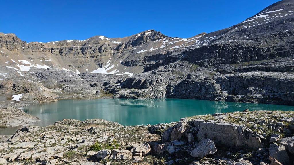
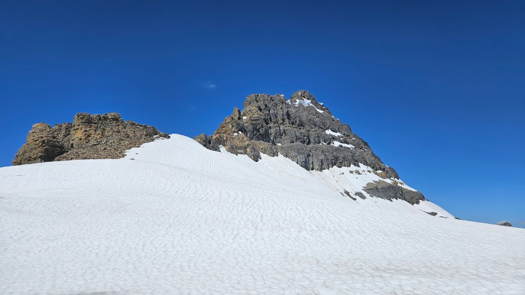
The lake in-of-itself is worth the hike in, but of course being us, we had bigger goals in mind that day. Our route would side-skirt the eastern side of Noseeum Lake to a series of cliff bands underneath Bearskin Peak. From under Bearskin, the route follows the ridgeline west then connects up to the main summit. This connector would undoubtedly be the crux of our day, and we mentally prepared ourselves for hands-on scrambling up the ledges to Bearskin. Having a crater-rim-like summit ridge, Noseeum boasts 4 peaks total and we briefly considered traversing the other two lower eastern peaks.
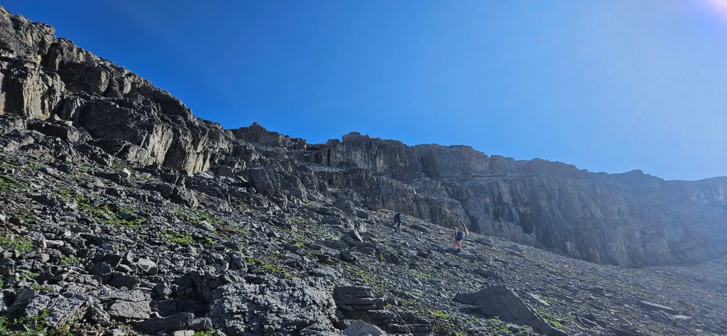
I believe we ruled these out in anticipating a long day, and wanted to preserve our energy levels for the difficult section near the top. Northeast of the lake we scrambled up fractured cliff bands and blocky ledges. These sections offered several brief stints of moderate hands-on scrambling but nothing too technical, however it pushed Robin towards the edge of his comfort zone. With minor route finding we made it to the base of Bearskin’s summit slope where we paused and briefly considered ascending Bearskin first. Alas, we wanted to attempt that route as energetically as possible so continued onwards towards Noseeum Peak.
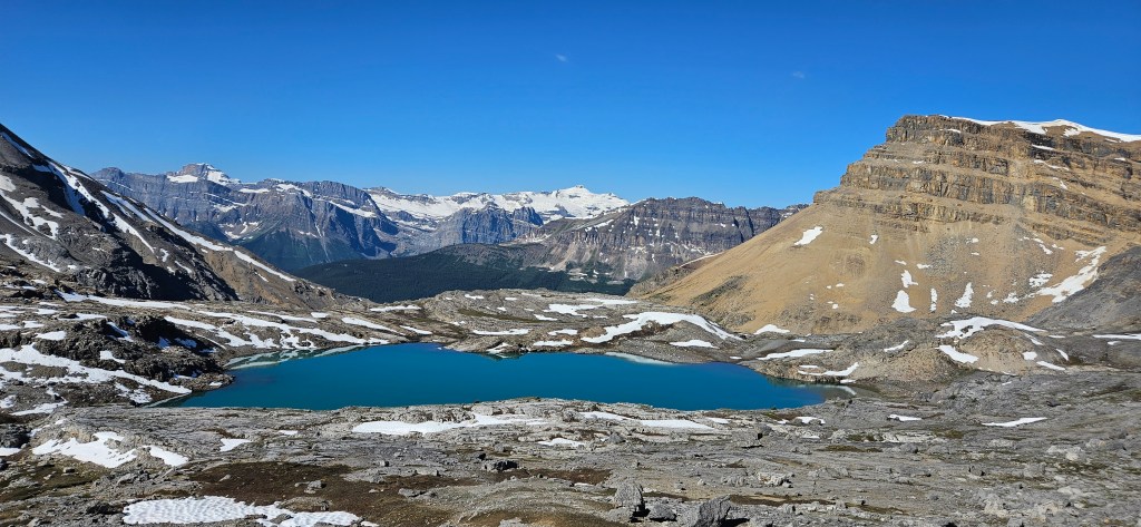

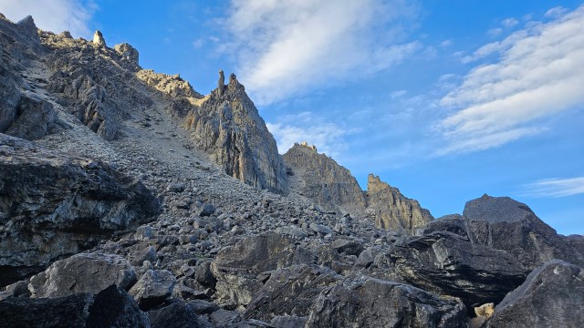
High above Molar Pass and Mosquito Creek, the views had already made the effort worth while at this point in the day. We thoroughly enjoyed the scenery leading up to the difficult section, and were eyeing the ridge intently trying visualize where the route actually went. To be frank, it looked both complex and very rotten rock quality. Plus, a fair amount of lingering snow dotted the upper reaches of this route.
In More Scrambles Nugara suggests that the worst of the route can avoided by kicking snow steps along the eastern flank, so I scouted ahead doing just that. In going this way I could somewhat see where to go next, and veered slightly north following the snow pack. However, being mid July, the snow was very isothermal and I suddenly sunk in chest-deep with the toes of my boots only just making contact with a very steep angled slab. It was an “oh-sh*t” moment and took some effort to bail myself out of the snow. Further beneath the snow patch the north side of the ridge crest drops off on a near 90 degree angle… sliding off from here would be fatal.
I backed away from this approach while still trying to figure up if there was a safe option up through the rocks. Lingering snow patches seemed to be blocking the way up above where I turned back from, and we did not want to chance a difficult scramble with partial snow coverage. We hiked back around the southern side of the crest, and maybe saw a way up but it was very exposed and committing… collectively the three of us decided to abandon the route.
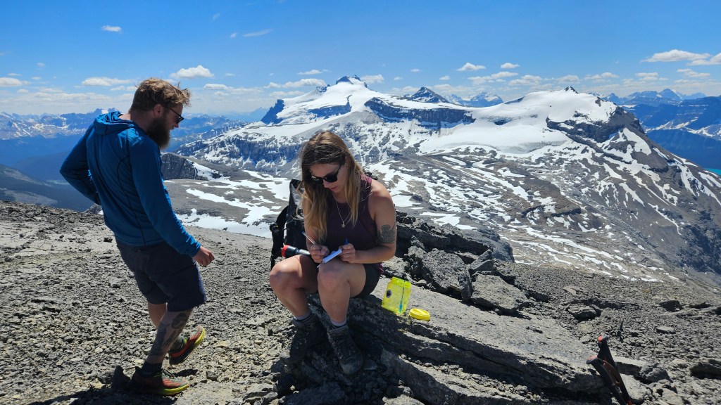
Wanting to salvage our day, and noting that there was still ample daylight, we opted to backtrack across the col and summit what we had still been referring to as Noseeum 3. This was a slog back across and up but a very scenic slog at that! It was at the top of Noseeum 3 that we found a homemade summit register where we learnt it had been nicknamed “Bearskin Peak”. We gladly signed the register and then observed another party going up Noseeum the moderate route via the scree ramp northwest of the lake.
The other party seemingly made it up the moderate route with minimal difficulty from what we could see. This had Bri and I musing over traversing the slopes underneath both summits to connect into the moderate scrambling route. We decided to go for it, and while a long side-hill traverse, at least we wouldn’t be losing much elevation in the effort. While nothing more than moderate scrambling was encountered during this long side-hilling effort, the footing was terrible and the slope quite exposed. This proved too much for Robin who promptly decided to find his own way back down at the lake and wait for us there.
Bri and I continued, and at first could see the ‘ramp’ feature of the moderate scrambling route. However as we got closure our view got obscured by the curve in the slope and in our fatigue misread the terrain by ascending one gully too soon (north). Bri scrambled up quickly into some very steep and exposed terrain, much more committing than what is described in More Scrambles which prompted me to re assess our position and ultimately make the call to back-off. We reluctantly dropped further down the slope and in doing so spotted the correct ascent gully.

On our way back to the lake, it became apparent that the correct gulley was only a few minutes west of us, but it was already late in the afternoon so we decided it was time to head home. It was frustrating but ultimately the right call as our day proved to be far from over. We still had a fair distance back to the lake, plus the hike out. Once regrouped with Robin we followed the outflow stream from the lake down through the second headwall towards the Upper Waterfall section. With the hot temperatures, alpine melt had turned up the outflow from Noseeum Lake and the creeks were turbulent. This increased waterflow had drastically changed the landscape beneath the second headwall, and despite retracing our exact steps from the morning with my Garmin watch, we felt lost. Very lost.
The Upper Waterfall was unrecognizable in its heavier outflow and we assumed (wrongly) that this must have been a different waterfall altogether. We zig zagged the cliff edge back and forth crossing numerous side branch streams while considering our options for at least a full hour. Most of this time was spent second-guessing ourselves and constantly encountering dead ends or cliffed-out sections. Eventually, we found some cairns leading back to the very same waterfall we had backed away from. Fatigue, late day sun and frustration mounted over the situation, but according to my GPS track it was on route, so we had been correct the whole time.
Eventually I spotted a broken section of the cliff several meters west of the upper falls. It was well treed and as offered lots of protection albeit at the cost of bushwhacking. We downclimbed this treed weakness in the slope fully avoiding the falls and shortly after linked back with the trail we had used that morning. It was a relief but we still had to find our way back through the first headwall and struggled to stay on any given route. We bush whacked our way down to the base of the first headwall and had to cross several braids of Noseeum Creek, before finally linking up with the main creek trail. It was a quiet stomp back to the car, and I didn’t record the exact return time, only noted it had been over 12 hours.
Needless to say it was a longer than expected day and it took a wee while before the three of us could laugh about it over beers, which thankfully we did a few weeks later. Bri and I would later return to complete the Moderate Scrambling route up Noseeum Peak in July 2025.
