
June 19th, 2025. Banff National Park, Alberta.
Round Trip: +11 Hours. Elevation Gain: 1200m
Moderate Scramble, minor route finding
Further reading: Kane’s (2016) Scrambles in the Canadian Rockies 3rd Edition
This was a big day for having only done two peaks earlier in the spring, and with nearly two week gaps between each outing. Bri and I managed to spark a widespread interest in this trip and had a total of nine others join us. It’s a rare thing to have so many eager spirits partake in a scramble! Naturally, the combination of a large group + early season adventuring led to a longer day. If in decent shape or in the midst of your hiking season, 8-10 hours would be realistic for this one.
This was a good induction scramble for the many novices in our group that day. It combined a long approach via a maintained trail, some minor bushwhacking, very minor route finding in the main gully, and easy to moderate hands on scrambling. Some sections got a little exposed due to the steep gradient but nothing overly crazy. To top it all off, this peak boasts an amazing summit panorama including views of Mount Assiniboine to the south.
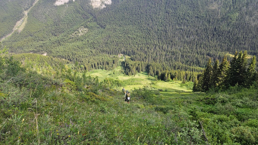
To everyone’s pleasant surprise we all managed to show up at the Redearth Creek carpark on time and had hit the trail by 8:20am. Following Kane’s (2016) description we hiked along Redearth Creek trail to Lost Creek campground, where the trail crosses the creek and switches back east. At first the footpath from the campground is narrow but defined at first. As we passed through a thicket of trees the path petered out and we briefly bushwhacked across a mix of meadow & forest until positioned under the correct gully. From the campground it was only 20 minutes to reach this spot, which is landmarked by a distinct dark grey “fin” shaped feature to the looker’s right when facing the gully.

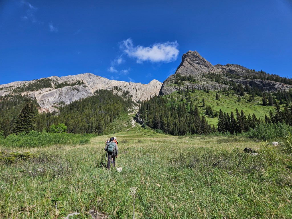
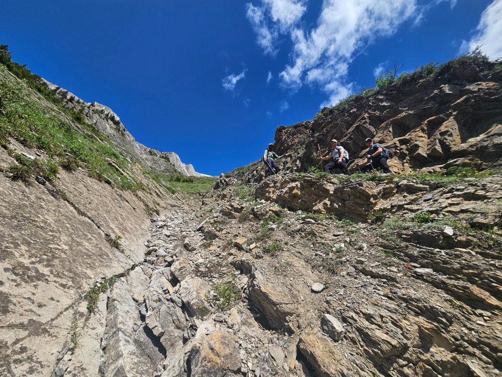
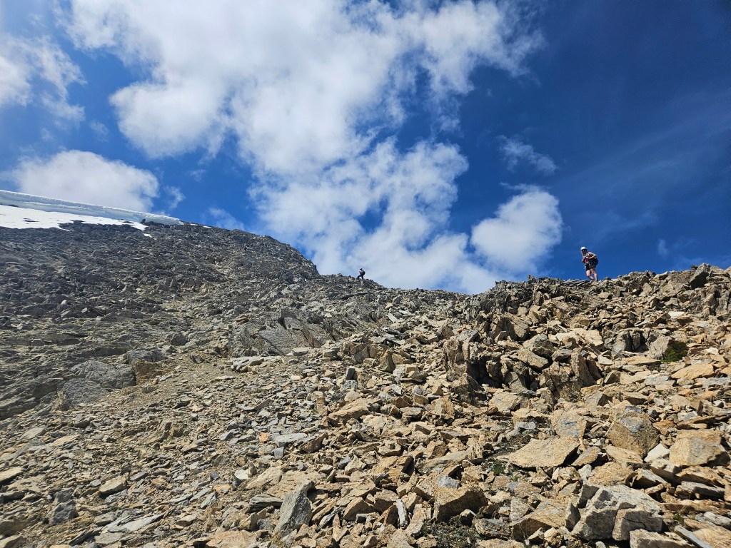
A little after 11am our crew found themselves above the meadow and entering the first main gully. Initially we stuck to the climber’s right where natural rock formations leant themselves well as a staircase and moral reminded high this early in the day. Within an hour the gradient steepened sharply and we found ourselves in 4×4 mode with easy to moderate hands on scrambling. This section began to wear down a few of our group as comfort levels were tested. We really had to spread out selves out with such a large group, while not the worst quality of rock there was still a considerable amount of debris being kicked down so helmets were essential.
Admittedly, towards the top of the gully we switched over to the climber’s left and in doing so unnecessarily ascended up a rib. I noted a distinct right-side turn in the gully we were meant to follow and pointed out that we had strayed too far left to gain it. Nathan, already an avid scrambler, managed to navigate his way up and over the rib back to the correct route. The way he went looked very technical and exposed, too technical for the inexperienced within our group, so the rest of us doubled back downhill to re-ascend the climber’s right side (east) of the gully. If stayed on route, we should have remained on the climber’s right for the entire first gully, which then tops out into a second gully making a brief sharp right-hand turn.
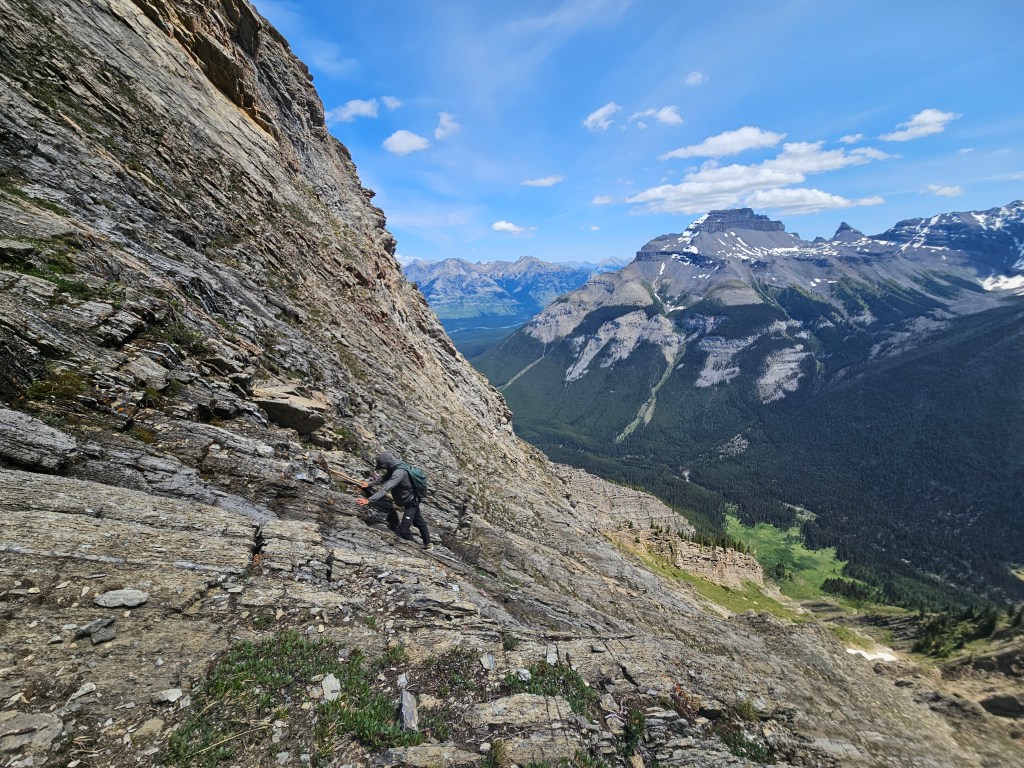

Once doubled down back in the gully we were picked a flatter section to traverse back to the climber’s right (east) and follow a ledge just above the gully’s edge. This felt much better and more fitting of the moderate rating for the route. We managed to get the whole group up this last section of the first main gully. Regrouped with Nathan, our route followed the notable sharp turn to the looker’s right (northeast) and continued up a second gully to a sizeable saddle-like notch overlooking a steep drop-off to the east. This provided a scenic rest stop where most of the group could all fit in for a seat and enjoy the views. Above us the route continued up more classic Rockies-rubble towards the summit ridge. Three party members (all of the same vehicle) decided here that they had enough with scrambling and opted to descend to the meadow where they would wait for our return.
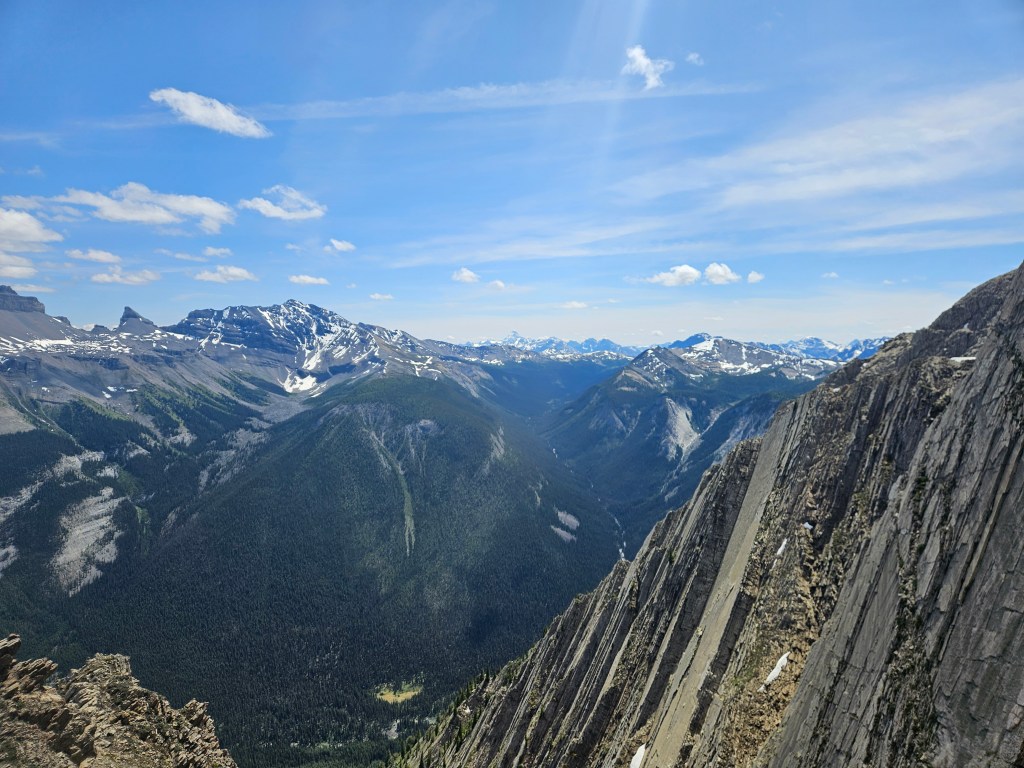
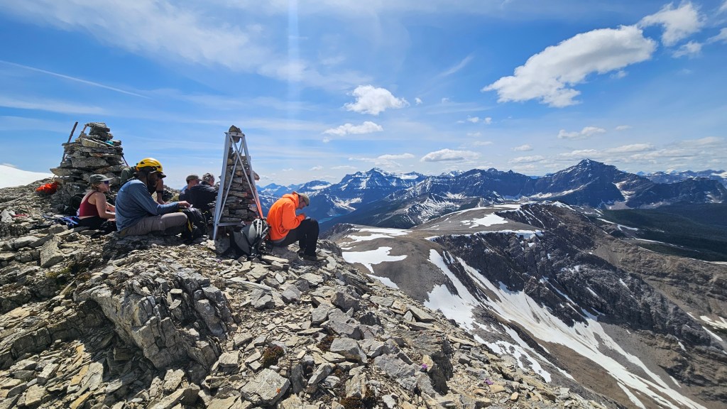
Unfortunately for those who turned back, things got much easier above the notch and the summit ended up being less than an hour away. Half an hour or so of easy scrambling up a slightly more defined footpath led us to the broad panoramic ridge that makes up Copper Mountain’s large summit. A leisurely 10 minute stroll with many photos along the way brought us to the summit proper, complete with a registry and an old metal cairn structure similar to the one I saw on Panorama Peak in 2016.
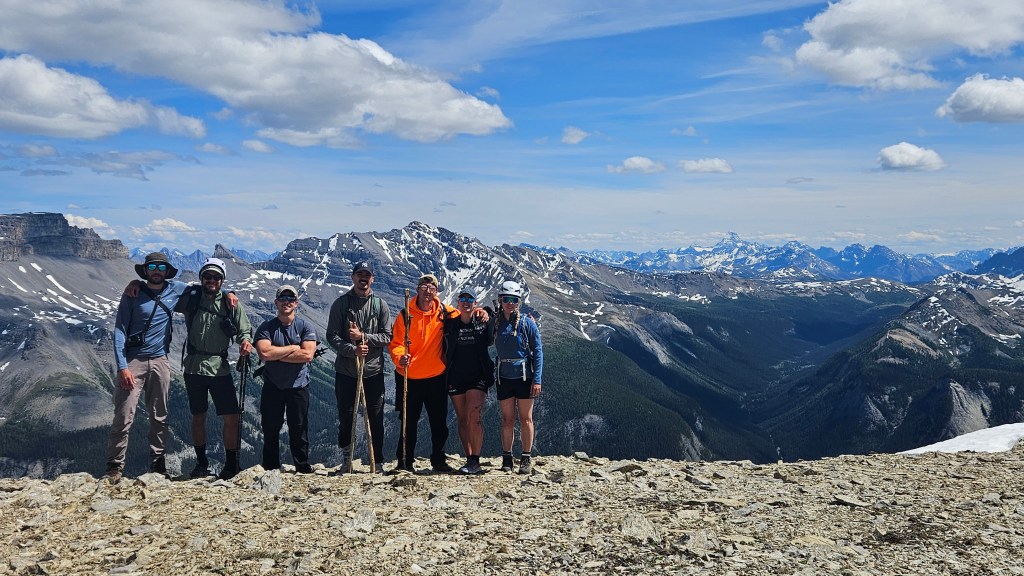
Eight of our crew of eleven made it to the summit and the stoke level for those who made it was high. I’d go as far to say that this is one of my favourite panoramas south of Lake Louise. We enjoyed a long well earned break, it had taken our crew 5.5 hours from car to summit including breaks and the detour mentioned earlier. Energy levels briefly returned while at the top but quickly waned with the down-sloped scrambling into the gullies. It would take almost the same amount of time as the ascent as for the return. As a safety precaution we spread the group out for the lower gully, as not everyone brought a helmet, and it was this last push back to the meadow that really gassed the group out.

It took nearly three hours for everyone to make it back down from the summit. Back in the meadow we regrouped with the other 3 party members who had earlier turned back at the notch. They had waited directly below the gully near Redearth Creek thus were easy for us to find. As a group we decided cut out a few kilometers on the return hike by not doubling back to Lost Creek Campground and instead cut straight across Redearth creek to the main trail. We anticipated a bit of bush whacking on the other (east) side of the creek but were all in agreement, so once the last few stragglers caught up from the gully we collected ourselves and pushed forward.
The creek crossing itself was easy enough, albeit was frigid cold. Regaining Redearth Creek Trail however proved to be a sting-in-the-tail to our day. It made sense to straight-line our way through the downed trees, however the volume of deadfall complicated this plan and we had to bushwhack through on an off-angled northeast line. Some of the deadfall was extremely decayed proving unstable footing in contrast to sharp branches and root balls. In following a northeast diagonal we eventually found the trail after an agonizing 10-15 minutes. Everyone was collectively exhausted at this point and we still had several kilometers to hike out back to our vehicles.
Once back on the trail, we learnt that one party member had lost their phone somewhere in the thicket after crossing the creek. Our overall group split up with some hiking out right away while a few stayed back to help find the missing phone. Bri and I’s group initially stayed behind unsure if we should wait for the others to find the phone or not. 10 minutes into waiting we opted to hike out and agreed to wait for the last group back at the carpark. It was a slow plod back, and thankfully we didn’t have to wait long for that last group to make it back.
Had we not spent the extra minutes waiting for that last group, we would have missed out on an incredible wildlife sighting during our drive home to Golden. A massive lone grey wolf causally crossed the highway in front of us near in western Yoho, and stared down our vehicle long enough that I had to make a near full-stop. Luckily no other vehicles were behind, so the whole carload had a good long view of the wolf before it decided to finish crossing the highway. An amazing end to the day!
